Dululu and Wowan
Historic flooding
Flooding in Dululu is primarily governed by breakout flows from the Dee River. Wowan is situated approximately 1.5km from the Dee River floodplain and it not vulnerable to regional flooding in most storm events. Flooding in Wowan is primarily governed by local flooding from Pocket Creek.
Extent of flooding
The below table explains the multiple Annual Exceedance Probability (AEP) flood events analysed as part of the Study. AEP indicates the probability of a flood event occurring each year expressed as a percentage. Flood probability can also be expressed as an Annual Recurrence Interval (ARI).
| Annual Exceedance Probability, AEP |
Approximate Annual Recurrence Interval, ARI |
Impact on Townships |
| 5% chance of occurring each year or 5% AEP |
Approximately 1 in 20 year event |
- Burnett Highway severed in both directions from Dululu
|
| 2% chance of occurring each year or 2% AEP |
Approximately 1 in 50 year event |
- Flooding impacts majority of buildings in Dululu
- Pocket Creek breaks its banks and inundates properties within Wowan
- Access via the Leichardt Highway between Dululu and Wowan restricted
- Dululu Community Hall and evacuation centre impacted
|
| 1% chance of occurring each year or 1% AEP |
Approximately 1 in 100 year event |
- Westwood Wowan Road to the north is severed
- Similar magnitude to the 2015 flood event
|
| 1% AEP event Climate Change (CC) sensitivity simulation or 1% + CC AEP |
Approximately 1 in 100 year event - adjusted for climate change sensitivity |
- Wowan Multi-Purpose Centre and evacuation centre impacted
- Identified in images below
|
| 0.05% chance of occurring each year or 0.05% AEP |
Approximately 1 in 2000 year event |
|
| A Probable Maximum Flood (PMF) event is the largest flood event that could occur at any given location. It is usually an estimated rainfall depth calculated using a range of methods and patterns. |
|
Considering the information above, the proposed areas of investigation to protect residents from the impact of flooding are shown below.
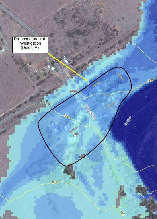
Image: Proposed area of investigation (Dululu) with 1% + CC AEP flood inundation depths shown
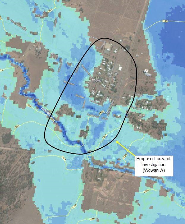
Image: Proposed area of investigation (Wowan) with 1% + CC AEP flood inundation depths shown
Potential flood mitigation options
Flood mitigation strategies are aimed at reducing residual risk, improving safety, minimising damage by reducing peak flood levels and depths, improving warning times and reducing flow velocities. This can be achieved through both structural and non-structural measures.
Some non-structural measures already form part of Council’s current Local Disaster Management Plan and Planning Scheme. After the completion of the Floodplain Management Plan, additional measures and updates to Council’s plans and schemes may occur.
Given the inundation maps above, there are multiple structural measures that could be implemented to reduce the flood risk in the proposed areas of investigation at Dululu and Wowan.
The structural measures identified that may reduce flood risk within the proposed areas of investigation include:
- Low levees, large levees or a combination of both to provide some level of flood protection to residents
- Individual property levees
- Raising of existing stumped houses.